Work in progress ...
Today we start the journey
home.
 |
| The G and me outisde our accommodation as we prepare to leave the Misty Isle |
We headed out through the Cuillin Hills. These come in two varieties
– red and black – and they give their name to the locally brewed Skye beer
(though I doubt the hops are grown on Skye). There are 15 Cuillin mountains
over 3000 ft – one called the Inaccessible Pinnacle (http://en.wikipedia.org/wiki/Sgùrr_Dearg
- InPin for short!) is the hardest.
The peaks of the Black Cuillin are mainly composed of
Gabbro, a very rough black igneous rock which provides a superb grip for
mountaineers, and basalt, which can be very slippery when wet. The Red Cuillin
(Na Beanntan Dearga in Gaelic) are sometimes known as the Red Hills. They are
mainly composed of granite which is paler than the gabbro (with a reddish tinge
from some angles in some lights) and has weathered into more rounded hills with
vegetation cover to summit level and long scree slopes on their flanks.
There is an established record for running up and down one
of these peaks – the Glamaig Hill Race record was broken last year by one
Finlay Wild in 44mins 27sesc. You have to see this feat to believe it but I
would love to have a go!
Then we proceeded to Claymore toward the road bridge to the
mainland. The bridge was opened in 1995 amidst much controversy. Leading the
opponents – not surprisingly – were the ferry companies. The bridge runs between
the villages of Kyle of Lochalsh on the mainland and Kyleakin on Skye’s east
coast.
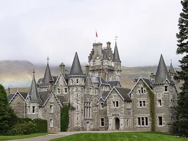
The loch between Kyle of Lochalsh and Kyleakin is Loch Duich.
On the edge of the loch is Castle Eilean Donan. The castle is constructed on a
tidal isaldn but was restired in the early 20th century when a
bridge was built. It’s incredibly picturesque and has been used as the setting
for films and television.
 |
| Castle Eilean Donan situated in Loch Duich |
 |
| Our heroes with Castle Eilean Donan and the Loch in the background |
 |
| Never let a castle come between you!! |
 |
| The castle from the top road |
As you approach Invermorriston there are more trees and the bleak highlands have gone and the trees are turning autumnal.
 |
| Bridge at Invermoriston (in some disrepair) designed by our friend Thomas Telford. This bridge is one of nearly a thousand built by Thomas Telford between 1804 and 1819. |
 |
| The angle of the bridge is unusual compared modern road layouts. You can see the damage in this picture |
 |
| From the Telford bridge looking downstream |
We drove along the northwestern bank of Loch Ness into Fort
Augustus. The water in Loch Ness is coloured dark by peat and is apparantenttly
almost completely opaque. So divers van see nothing – or little – even with
lights and this is why the Loch Ness Monster has never been found!! The story
of the monster is very old. St Columba (remember him from Iona? he was 6th
century) came here and met a man who knew a man had been attacked by a water
beast. Columba got in the water and genuflected to drive away the monster.
Loch Ness is the second largest Scottish loch by surface area at 56 km2 (21.8 sq miles) after Loch Lomond, but due to its great depth, it is the largest by volume. Its deepest point is 230 m (755 ft) making it the second deepest loch in Scotland after Loch Morar (310 m (1,017 ft)). It contains more fresh water than all the lakes in England and Wales combined.
Loch Ness is the second largest Scottish loch by surface area at 56 km2 (21.8 sq miles) after Loch Lomond, but due to its great depth, it is the largest by volume. Its deepest point is 230 m (755 ft) making it the second deepest loch in Scotland after Loch Morar (310 m (1,017 ft)). It contains more fresh water than all the lakes in England and Wales combined.
The village takes its name from a fort built after the defeat of the 1715 Jacobite uprising. Almost nothing remains of the original fort today, although some parts were built into the Benedictine Abbey in 1876 and was inhabited by monks until as recently as 1998.
 |
| The locks at Fort Augusta. There is a staircase of 5 locks |
Fort Augustus is commercial but still retains its charm at
the head of Loch Ness where it feeds the Clyde Canal. The Clyde Canal is
connected to the Union Canal which we sailed upon on Day 10 (www.g-and-t-uktour2014.blogspot.com.au/2014/09/day-10-tension-mounts-yes-or-no.html).
 |
| A glass of beer and some smoked trout at The Lock Inn. |
 |
| From the bridge at Fort Augusta down the canal to the head of Loch Ness. No monsters in sight today |
 |
| I love these kinds of memorials. This man must have been well-respected |
We passed along the side of Loch Laggan. Here one can find the
castle of Ardverikie (www.ardverikie.com).
This was used for the Monarch of the Glen series and now has self-catering
accommodation. It was nearly a royal residence in Scotland.
 |
| Nearly a royal residence: the castle of Ardverikie |
Queen Victoria and Prince Albert first visited
Scotland in 1842, five years after her accession to the throne and two years
after their marriage. During this first visit they stayed at Edinburgh, and at
Taymouth Castle in Perthshire, the home of the Marquess of Breadalbane. They
returned in 1844 to stay at Blair Castle and, in 1847, when they rented
Ardverikie by Loch Laggan. During the latter trip they encountered weather that
was extremely rainy, which led Sir James Clark, the queen's physician, to
recommend Deeside instead, for its more healthy climate Cairngorms National
Park.
 |
| A rainbow over the Cairngorms |
We stopped at Spean Bridge. I would have said that Spean Bridge had nothing to recommend it. Wikipedia describes it as a "transport link" and that's pretty much what it looks like. There is, however, a whisky shop there!! It's not true that it has nothing to recommend it; I learn that the Spean Bridge is another Telford bridge.
We drove along the edge of the River Spean heading for Spean Bridge. A few miles upstream from Spean Bridge there is a dam which Sue told us was called the Clooney Dam. In fact this is the Laggan Dam which creates a reservoir of the River Spean before it feed Loch Laggan. Sue said that the dam was named after George Clooney who had vacationed in nearby. Now the Mother (remember her) had all the gullibility of the Classic American and believed this!!
We drove along the edge of the River Spean heading for Spean Bridge. A few miles upstream from Spean Bridge there is a dam which Sue told us was called the Clooney Dam. In fact this is the Laggan Dam which creates a reservoir of the River Spean before it feed Loch Laggan. Sue said that the dam was named after George Clooney who had vacationed in nearby. Now the Mother (remember her) had all the gullibility of the Classic American and believed this!!
 |
| Looks like all the others really! |
We passed the Dalwhinnie distillery (oddly I cannot find a
website but see www.discovering-distilleries.com/dalwhinnie)
but did not stop. Dalwhinnie is a fine drop but not today. We still had Bowmore
in the hip flask so we made do with that!!
The road that runs past the Dalwhinnie Distillery is called General Wade's Military Road. Field Marshal George Wade (1673 – 1748) was a British Army officer who served in the Nine Years' War, War of the Spanish Succession, Jacobite rising of 1715 and War of the Quadruple Alliance before leading the construction of barracks, bridges and proper roads in Scotland. He went on to be a military commander during the War of the Austrian Succession and Commander-in-Chief of the Forces during the Jacobite rising of 1745.
The road that runs past the Dalwhinnie Distillery is called General Wade's Military Road. Field Marshal George Wade (1673 – 1748) was a British Army officer who served in the Nine Years' War, War of the Spanish Succession, Jacobite rising of 1715 and War of the Quadruple Alliance before leading the construction of barracks, bridges and proper roads in Scotland. He went on to be a military commander during the War of the Austrian Succession and Commander-in-Chief of the Forces during the Jacobite rising of 1745.
Sue has been an excellent guide – but then she has been
doing it for nearly 20 years so it should come naturally. She is a great
raconteur and you realise that the task of a tour guide is full-on while the
tour is going. She had lain awake last night worrying about how she would fit
everything people wanted to do, not just in terms of logistics but in terms of
fitting around the restriction son her daily driving hours. She told us stories
of people who had broken limbs, lost things – all sorts of calamities. And they
all need to be dealt with. It’s a bit like being the captain of a ship I
suppose. It does make you wonder how they hire these people who, at the end of
the day, are performers. Their job is to entertain and inform and look after
the people on the tour.
 |
| Would you buy this chair? |
We made a longish stop at Bruar where we found the House of
Bruar (www.houseofbruar.com) which is a very flashy up market emporium with a magnificent food hall.
You can also buy – at huge cost – all sorts of things that you do not really
need such as a chair covered in tartan and made from stag antlers. This chair
was about as hideous and artefact as you could imagine, but I expect some Asian
will think is lovely and pay the £1,500 price ticket.
There was a grocery section where there was red cabbage at 99p
for 100g!!! We grew these in the garden and I reckon ours weighed at least a
kilogram making them worth £9.90 each (about $20)!!
 |
| The mighty Tummel coursing through the glen |
We crossed the River Tummel which is fed by Loch Rannoch.
This is near Pitlochry which we saw as we drove by. I noticed that Pitlochry is
the home of the Pitlochry Highland Games (www.pitlochryhighlandgames.co.uk).
By now the landscape is beginning to lose that rugged highland look. The tall
and menacing grey and green slopes are giving way to much gentler countryside. We
could see the Atholl Palace Hotel (http://www.athollpalace.com)
from the window – most impressive!! Definitely a place to stay!!
The Atholl Palace Hotel is but one example of a number of
big houses built in the 19th century. Following the clearances, the
land opened up as a playground and the wealthy would go hunting, shooting and
fishing. And clearly they needed a house to base themselves in!!
We drove back in beautiful sunshine autumn as we crossed the
River Tay which is the longest river in Scotland and the seventh-longest in the
United Kingdom. The salmon fishing is excellent. The British record salmon
weighing in at 64lb salmon was caught by Miss Georgina Ballantine in 1922.
Coming into Perth we drove past Birnam Woods – as in Shakespeare’s
Macbeth. You know the bit in Act 5 Scene 3 where Macbeth says:
Bring me no more
reports; let them fly all:
Till Birnam wood
remove to Dunsinane,
I cannot taint with
fear. What's the boy Malcolm?
Was he not born of
woman? The spirits that know
All mortal
consequences have pronounced me thus:
“Fear not, Macbeth; no
man that's born of woman
Shall e'er have power
upon thee.”
We noticed that the Ryder Cup (http://www.rydercup.com) is on in Perth –
more specifically at the Glenagles Hotel (www.hotel-gleneagles.com). Readers
will know that my sporting knowledge can be fitted onto a pinhead so it was
only when I saw a picture that I realised this all about golf!! I did notice
that Harry Potter reentered the reckoning as we passed Dobbies Garden Centre (www.dobbies.com).
 |
| Firth of Forth road bridge |
We drove into Edinburgh over the Firth of Forth road bridge
which was 50 years old last weekend. There is a new road bridge being built. We
had a magnificent view of the railway bridge which I described on Day 13 (www.g-and-t-uktour2014.blogspot.com.au/2014/09/day-13-whisky-go-go.html).
The G noticed our accommodation and with a hue and cry we shouted
to Sue to stop and we unloaded. Tonight we are in a B&B in Randolph
Crescent. This is a magnificent Georgian terrace dating apparently from 1728.
We checked in to a lovely room and then went off for the nose-bag. We found a
place called the Rosehip (www.therosehipedinburgh.com)
in Rose Street and enjoyed a passable meal there washed down by a Pimms!!
 |
| The Rosehip |
No comments:
Post a Comment